Estuary Circulation & Salinity Models
Senate Bill 137 (1975), House Bill 2 (1985), Senate Bill 683 (1987), and other legislative directives called for the Texas Water Development Board (TWDB) to maintain a data collection and analytical study program focused on determining freshwater inflow needs which are supportive of economically important and ecologically characteristic fish and shellfish species and the estuarine life upon which they depend. More recent legislative directives, Senate Bill 1 (1997) and Senate Bill 3 (2007), also direct TWDB to provide technical assistance in support of regional water planning and development of environmental flow regime recommendations, which include consideration of coastal ecosystems. As part of this effort, TWDB developed, maintains, and utilizes two-dimensional (2D) depth-averaged and three-dimensional (3D) hydrodynamic and salinity transport models which are capable of producing high-resolution, dynamic simulations of estuarine circulation and salinity patterns over long-term periods covering a year or more. Because the models simulate currents and salinity conditions as a function of freshwater inflow, tides, wind, and precipitation/evaporation, they are an essential tool to use when evaluating changes in bathymetry (dredging, reef building, storm impacts), water level, and freshwater inflow management (reduced volume, altered timing of inflows, increased salinity).
The complexity of the Texas coast offers unique challenges to numerical modeling. As well as mathematical and computational limitations, the accuracy of the models also is constrained by the quality and availability of data required to calibrate the model and run simulations. A detailed description of the data needed to run these models is given in the Model Inputs section below. In an effort to improve modeling capabilities, the TWDB has developed in-house software, modified external software, and funded research to improve the physics and understanding of the models. TWDB also funds data collection programs and collaborates with other agencies to obtain the data required for these models.
TxBLEND Model
TxBLEND is a version of the BLEND model, developed by Dr. William Gray of Notre Dame University, which was modified by TWDB engineers for use in the shallow bays and estuaries of Texas. TxBLEND is a two-dimensional (vertically-averaged) finite-element model which solves the continuity equation, momentum equations, and the advection-diffusion equation for conservation of salt. The model uses unstructured, numerical grids based on the bathymetry of each bay. Each bay model may have one or more inflow points which correspond to natural drainages into the estuary. Model output includes time-varying depth and vertically-averaged horizontal velocity components of flow and salinity throughout the model domain. TxBLEND thus provides water velocity, surface elevation, and salinity at each node in the model grid. The model does not provide information about vertical variation within the water column, but rather provides information about horizontal variation, such as salinity zonation patterns throughout the estuary.
TWDB has calibrated and validated TxBLEND models for all seven of the major estuaries in Texas including Sabine Lake, Galveston Bay, Matagorda Bay, San Antonio Bay, Aransas and Copano Bays, Corpus Christi Bay, and the Upper and Lower Laguna Madre. TWDB also has multi-bay models, such as for the bays in the Coastal Bend. TWDB has developed a series of reports which document the calibration and validation of TxBLEND for the major estuarine systems. These reports plus other studies utilizing the TxBLEND model are listed below.
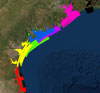 Click on the image on the left to access a map of the TxBLEND grid nodes for seven TxBLEND hydrodynamic and salinity transport model grids. Within the map individual nodes can be selected to generate a popup with the node number and the associated coordinates.
How does bay modeling support other Texas programs?
TxBLEND is the primary hydrodynamic model used by TWDB and has been used in past State freshwater inflow studies and by all of the Texas Senate Bill 3 Basin and Bay Expert Sciences Teams in their effort to develop freshwater inflow recommendations for Texas estuaries. Because TxBLEND produces high-resolution, dynamic simulations of estuarine conditions over long-term periods, the model has been used in a variety of projects. One important application is to forecast water currents for oil spill response as part of the Texas General Land Office (TGLO) Oil Spill Prevention and Response effort. For this effort, TxBLEND model simulations of water circulation in the major bays are maintained in near real-time and forecast modes. For bays with heavy ship traffic, these models quickly provide information to TGLO responders on the potential path of an oil spill. Models also have been applied to study the effects of man-made structures and practices on bay circulation and salinity.
What three-dimensional models have been developed for Texas estuaries?
While TxBLEND continues to be the principal hydrodynamic model used by TWDB for estuary analysis, staff have taken advantage of recent advances in modeling technology and computational speed as well as new modeling needs to develop and evaluate various state of the art 3-D baroclinic hydrodynamic models. An ongoing model comparison project is underway to help us better understand the strengths and weaknesses of each model and their abilities to accurately model the physical processes that are important in understanding Texas coastal systems. The models that are part of this comparison are SELFE, UTBEST and FVCOM.
SELFE Model
In recent years, TWDB staff has applied SELFE, an unstructured-grid hydrodynamic and salinity transport model designed for effective simulation of 3-D baroclinic circulation across river-to-ocean scales (Zhang and Baptista 2008) for special projects in Texas estuaries. SELFE uses a semi-implicit finite-element Eulerian-Lagrangian algorithm to solve the shallow water equations and is written to realistically address a wide-range of physical processes, including atmospheric, oceanic, and riverine forcings. It also naturally incorporates the wetting and drying of tidal flats. SELFE has been extensively tested against standard ocean/coastal benchmarks and applied to a number of bays and estuaries around the world (Foreman et al. 2005, Oliveira et al. 2006, Dias et al. 2009, Wang et al. 2008). It has been used and tested internally by TWDB for several years (Zhang 2006, 2008, 2010).
TWDB staff first used the SELFE model to simulate water circulation and salinity transport in the Keith Lake/Salt Bayou wetland complex in Jefferson County. The model was successfully applied to evaluate the use of passive siphons as a means for mitigating salinity in the wetland complex (Pothina and Guthrie 2009). Staff presently is applying the model to Corpus Christi Bay and the Brazos River Estuary.
SELFE is developed by Oregan Health and Science University (OHSU) and is freely available from the developer website. A list of peer reviewed publications also is available. TWDB has funded prior research for SELFE and its predecessor ELCIRC.
Computational Resources
TWDB mainly uses high-end multi-core linux workstations to run hydrodynamic simulations. State-of-the-art three-dimensional unstructured grid hydrodynamic and transport models that have been applied to Texas bays such as SELFE, FVCOM, and UTBEST3D are parallelized over Message Passing Interface (MPI) for multi-core simulations. TWDB staff use a 188-core high-performance computing (HPC) cluster for running computationally intensive hydrodynamic models. This HPC cluster enables running long-term simulations at speeds exceeding 100x real-time, thus making it possible to increase model grid resolutions for better accuracy. In addition, when there has been a need to run multiple scenario runs, staff has utilized The University of Texas supercomputers, Lonestar and Ranger, through research collaboration with Dr. Clint Dawson, head of the Computational Hydraulics Group.
Model Inputs
River Inflows
Rivers provide the dominant source of freshwater inflow to the estuaries. Model input for most applications of TxBLEND relies on daily inflow values taken from the TWDB Coastal Hydrology dataset for a specified estuary. While these datasets extend back as far as 1941, inflow values are applied only as needed depending on the time period of the model run.
Inflow datasets use measurements of streamflow from U.S. Geological Survey (USGS) stream gages in gaged watersheds along with rainfall-runoff estimates from the Texas Rainfall-Runoff (TxRR) model to estimate streamflow in ungaged watersheds. Ungaged flows then are adjusted for known industrial, municipal, and agricultural diversions and return flows which are obtained from the Texas Commission on Environmental Quality (TCEQ), the South Texas Water Master, and TWDB Irrigation Water Use estimates.
Meteorology
Time-varying and spatially uniform meteorology data is used to drive the models, including wind field, air temperature, precipitation, and evaporation. A large portion of the meteorology data (wind speed and direction and air temperature) is obtained from the National Climatic Data Center (NCDC) or the Texas Coastal Ocean Observation Network (TCOON). Evaporation data is calculated based on the Harbeck Equation (Brandes and Masch 1972) using temperature data from the NCDC. ' Precipitation data is obtained from the National Weather Service and TWDB archived records and is processed to provide an estimate of precipitation across the modeled estuary.
Tides
Gulf tides are measured along the Texas coast by the Texas Coastal Ocean Observation Network (TCOON) in cooperation with the National Oceanic and Atmospheric Administration (NOAA). TWDB applies measured tides and, in some cases, forecasted tides based on these measurements at the Gulf open boundary for each model.
Selected TxBLEND Reports
- Matsumoto, J., C.G. Guthrie, D. Crockett, T. McEwen. 2014. TxBLEND Model Extension and Salinity Validation for the Sabine-Neches Estuary: Extending Simulations Through 2013. October 15, 2014 Texas Water Development Board, Austin, Texas. 24pp.
- Guthrie, C.G., C. Schoenbaechler, J. Matsumoto, S. Negusse, T. McEwen, and D. Crockett. 2014. Development of a Galveston Bay TxBLEND Hydrodynamic and Salinity Transport Model Through the Historic Drought of the 1950's. March 10, 2014 Texas Water Development Board, Austin, Texas. 101 pp.
- Guthrie, C.G., C. Schoenbaechler, J. Matsumoto, and Q. Lu. 2012. TxBLEND Model Calibration and Validation for the Trinity-San Jacinto Estuary. March 22, 2012 Texas Water Development Board, Austin, Texas. 56 pp.
- Schoenbaechler, C., C.G. Guthrie, J. Matsumoto, and Q. Lu. 2011. TxBLEND Model Calibration and Validation for the Laguna Madre Estuary. October 27, 2011. Texas Water Development Board, Austin, Texas. 60 pp.
- Schoenbaechler, C., C.G. Guthrie, J. Matsumoto, Q. Lu, and S. Negusse. 2011. TxBLEND Model Calibration and Validation for the Nueces Estuary. July 26, 2011. Texas Water Development Board, Austin, Texas. 72 pp.
- Guthrie, C.G., C. Schoenbaechler, J. Matsumoto, and Q. Lu. 2011. Comparison of Two Hydrology Datasets, as Applied to the TxBLEND Model, on Salinity Condition in Nueces Bay. July 11, 2011. Texas Water Development Board, Austin, Texas. 13 pp.
- Schoenbaechler, C., C.G. Guthrie, J. Matsumoto, Q. Lu, and S. Negusse. 2011. TxBLEND Model Calibration and Validation for the Lavaca-Colorado Estuary and East Matagorda Bay. February 14, 2011. Texas Water Development Board, Austin, Texas. 72 pp.
- Guthrie, C.G., J. Matsumoto, and Q. Lu. 2010. TxBLEND Model Validation for the Upper Guadalupe Estuary Using Recently Updated Inflow Data. November 2010. Texas Water Development Board, Austin, Texas. 25 pp.
- Guthrie, C.G., J. Matsumoto, and Q. Lu. 2010. TxBLEND Model Calibration and Validation for the Guadalupe and Mission-Aransas Estuaries. July 2010. Texas Water Development Board, Austin, Texas. 46 pp.
- Matsumoto, J., G. L. Powell, D.A. Brock, C. Paternostro. 2005. Effects of Structures and Practices on the Circulation and Salinity Patterns of Galveston Bay, Texas. Prepared for the Galveston Bay Estuary Program. Texas Water Development Board, Austin, Tx. 138pp.
Selected SELFE Reports
- Pothina, D., and C. Guthrie. 2009. Evaluating Inverted Siphons as a Means of Mitigating Salinity Intrusion in the Keith Lake/Salt Bayou System, Jefferson County, Texas. Prepared for the Environmental Protection Agency Gulf of Mexico Program. Texas Water Development Board, Austin, Tx. 105pp.
- Zhang, Y. J. 2010. Final Report of Technical Support: Inter-model Comparison for Corpus Christi Bay Testbed. Report to the Texas Water Development Board. Oregon Health & Science University, Oregon. 18pp.